Duane Allman was born on November 20, 1946 in Nashville, TN. His younger brother, Gregg, was born in 1947. Together they would create one of the most popular and influential bands of all time: The Allman Brothers.
Having learned guitar from their grandmother, the Allmans would form multiple bands before creating the famous Allman Brothers, such as the Escorts, Allman Joys and the Hour Glass. They opened for successful bands, such as The Beach Boys.
The band prepared for their first album by constantly rehearsing and playing free concerts in Macon and Atlanta before settling on the name The Allman Brothers Band for their band and first album. The album was a huge hit leading to more opportunities to play with great artists, such as Eric Clapton.
Duane Allman would release two more albums with The Allman Brothers Band, Idlewild South and At Fillmore East. Sadly, during a break after the success of Fillmore East, Duane Allman was involved in a fatal motorcycle accident in Macon on October 29, 1971. Allman crashed his motorcycle after a lumber truck braked unexpectedly in front of him. He tried to swerve out of the way, but crashed. His motorcycle landed on top of him and slid, with him pinned under it, 90 feet, crushing his internal organs. He would die later on in the hospital.
Duane Allman is now buried at Riverside Cemetery in Macon. The Allman Brothers Band member Berry Oakley died 13 months later in a similar motorcycle accident and is buried next to his bandmate and friend.
Tuesday, November 27, 2012
Monday, October 22, 2012
Lab -Rockin' & Rollin'
Sedimentary - Limestone:

Limestone is mostly made up of Calcite and Aragonite. It tends to contain fossil remains of small organisms like coral. Most caves are made up of Limestone and it makes up around 10% of all sedimentary rocks. Limestone can also be used in building projects.
Igneous - Granite:

Granite consists mostly of Mica, Quartz, and Feldspar. By definition, it must contain at least 20% Quartz. The stone is always massive and very sturdy, making it ideal for many construction projects requiring a tough foundation e.g. Granite counter tops. It can be several different colors, depending on the minerals contained within the rock, most notably the amount of Feldspar which determines if it is white or pink.
Metamorphic - Gneiss:

Gneiss is mostly made up of Mica, Chlorite, and similar minerals. It is metamorphosed from igneous rocks. Because of this, there are several different types of Gneiss, such as Bioite Gneiss, Albite Gneiss, etc., all of which comes from these igneous rocks.
Soil Texture Diagram
 Twelve Soil Orders of the World

http://www.ga.nrcs.usda.gov/technical/soils/mlra136.html

The dominant soil orders in this MLRA are Ultisols, Inceptisols, and Alfisols. The soils in the area dominantly have a thermic soil temperature regime, a udic soil moisture regime, and kaolinitic or mixed mineralogy. They are shallow to very deep, generally well drained, and loamy or clayey. Hapludalfs (Enon and Wilkes series), Hapludults (Badin, Nason, and Tatum series), and Kanhapludults (Appling, Cecil, Georgeville, Herndon, Madison, Pacolet, and Wedowee series) formed in residuum on hills and ridges. Dystrudepts (Chewacla series) formed in alluvium on flood plains. Udults in the Rhodic subgroup (Davidson, Hiwassee, and Lloyd series) formed in old alluvium on stream terraces or in residuum derived from mafic rocks.
Limestone is mostly made up of Calcite and Aragonite. It tends to contain fossil remains of small organisms like coral. Most caves are made up of Limestone and it makes up around 10% of all sedimentary rocks. Limestone can also be used in building projects.
Igneous - Granite:
Granite consists mostly of Mica, Quartz, and Feldspar. By definition, it must contain at least 20% Quartz. The stone is always massive and very sturdy, making it ideal for many construction projects requiring a tough foundation e.g. Granite counter tops. It can be several different colors, depending on the minerals contained within the rock, most notably the amount of Feldspar which determines if it is white or pink.
Metamorphic - Gneiss:
Gneiss is mostly made up of Mica, Chlorite, and similar minerals. It is metamorphosed from igneous rocks. Because of this, there are several different types of Gneiss, such as Bioite Gneiss, Albite Gneiss, etc., all of which comes from these igneous rocks.
Soil Texture Diagram
http://www.ga.nrcs.usda.gov/technical/soils/mlra136.html
The dominant soil orders in this MLRA are Ultisols, Inceptisols, and Alfisols. The soils in the area dominantly have a thermic soil temperature regime, a udic soil moisture regime, and kaolinitic or mixed mineralogy. They are shallow to very deep, generally well drained, and loamy or clayey. Hapludalfs (Enon and Wilkes series), Hapludults (Badin, Nason, and Tatum series), and Kanhapludults (Appling, Cecil, Georgeville, Herndon, Madison, Pacolet, and Wedowee series) formed in residuum on hills and ridges. Dystrudepts (Chewacla series) formed in alluvium on flood plains. Udults in the Rhodic subgroup (Davidson, Hiwassee, and Lloyd series) formed in old alluvium on stream terraces or in residuum derived from mafic rocks.
Saturday, October 6, 2012
Lab: Plants of Mercer
Bush/Shrub: Lora Petalum

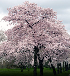


Tree: Yoshino Cherry
Flower: Daylilies
Bush/Shrub: Itea
Tree: Pecan Tree
Flower: Marigold
Bush/Shrub: Crepe Myrtle
Tree: Magnolia Grandiflora
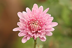
Flower: Chrysanthemum
Measuring a Tree
Tree 1: 1900cm + 155cm = 2055cm = 20.55 m tall
Tree 2: 2660cm + 155cm = 2815cm = 28.15 m tall
Friday, September 28, 2012
Lab 2 - Ocmulgee River
River Flow -
To measure the rate of flow of a river (how fast it flows), one must simply allow an object to float a predetermined distance and measure how long it takes for the object to travel said distance. In our case, we used an empty soda bottle that floated well and took around three minutes to travel to our endpoint. This simple act is useful in determining how strong the river's flow is, which can help determine if there is anything hazardous potentially blocking the river's flow upstream.

River Transect -
This task was performed with two poles tied together with a long string. The poles would be placed apart from one another until the string was taut. A hanging level would then insure that the line was even between the two poles. The string would line up with a mark on each of the poles, and the difference between the two marks the difference in elevation. This is an extremely useful tool in measuring depth which can be very helpful in times of drought when water levels need to be measured.

Clam Gathering -
To gather clams, you must simply scoop up sand with a shovel, pour the sand into a filter, and run water through it. While you can continue filtering to find finer items, the larger clams will stand out at the beginning. This is useful in determining where clams can be found and why they habituate those areas. We found that clams liked moist areas and would most likely be found in sand under the water. Areas that were above the water, but still moist, were also home to several clams. Areas that were dry were void of clams.
Monday, September 3, 2012
Lab 1 - Maps
Choropleth Map -


A choropleth map is a map where areas are shaded based on a statistical proportion. It is used to compare a variable in different areas, such as rates of child suicides in various Minnesota counties, as outlined in the chart above.
Dot Density -
A dot density map uses dots, scattered across an area to represent a phenomenon. It can be used to display a high number of people, objects, or anything else that may be measured, such as shown above, with each dot representing ten people. The specific location of each dot is not important, but rather the area it covers. And speaking of density...
Proportional Symbol -
A proportional symbol map shows aspects of a physical, social, economic, etc. nature, where each symbol is proportionately bigger or smaller to easily see the differences between the areas shown on the map, as seen above, comparing counties with larger and smaller populations of people older than 65 in Buffalo, NY.
Topographical -
A topographical map illustrates differences in sea level, indicating steepness using the proximity of the lines to one another. This map is excellent for producing a more accurate idea of the lay of the land of an area as it does account for how high above sea level some areas may be.
Hurricane Isaac -
Subscribe to:
Posts (Atom)